Port of Jorf Lasfar: A Maritime Nerve Center in the Maghreb
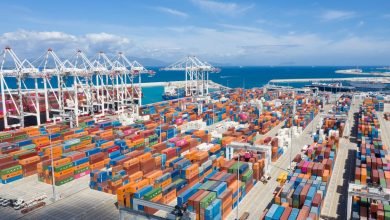
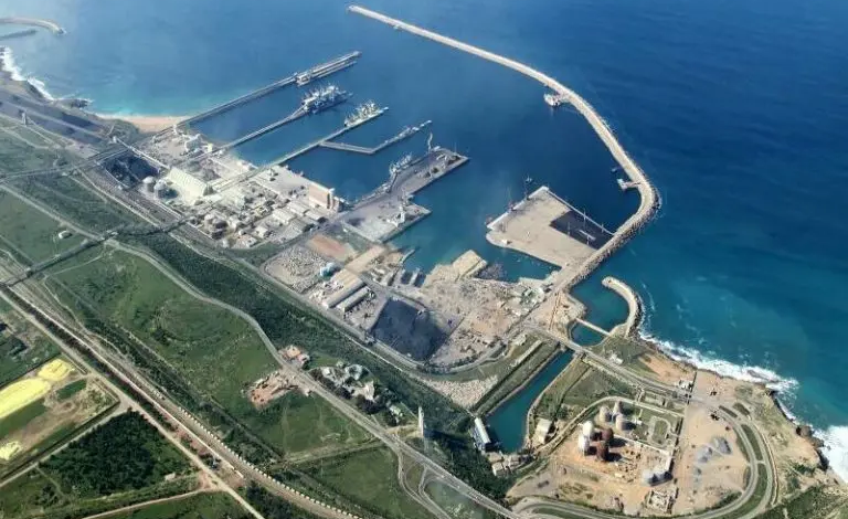
The port of Jorf Lasfar is a mineral and conventional port located 17 km from El Jadida and 120 km from Casablanca. Nearby, there are OCP factories, a thermal power plant, and hydrocarbon storage units. The port is expandable and benefits from unique handling capabilities. It was certified ISPS in 2004. It enjoys a favorable geographical location in a region experiencing significant economic, social, industrial, agricultural, cultural, and tourist development. The port is characterized by significant underwater depths (5 to 14 m of draft); a well-developed network of roads, railways, and telecommunications provides excellent connectivity with its surroundings. Its hinterland is rich in mineral extraction activities (Benguerir and Youssoufia).
Characteristics
- ◊ Location: 33°7’N-8°38’O;
- ◊ Purpose: Trade and fishing;
- ◊ 2 Entrances, North and South:
- – 1st entrance: road and rail to the South;
- – 2nd entrance: road to the North.
- ◊ Road access:
- – Rural road 301 connecting El Jadida to Safi;
- – Rural road 316;
- – National Route 1.
- ◊ Rail access:
- – Nouasseur-Jorf Lasfar line.
- ◊ Infrastructure:
- – Berthing quays: 2400 m;
- – Draft: between 5 and 14 m deep;
- – Land area: 110 ha.
History
Construction of the port began in 1974, and it commenced operations in 1982. Traffic increased from 74,263 tons in 1982 to 18,645,473 tons in 2012, and the number of vessels grew from 4 at the end of 1982 to 1,130 in 2012.
The port of Jorf Lasfar is a mineral and conventional port located 17 km from El Jadida and 120 km from Casablanca. Nearby, there are OCP factories, a thermal power plant, and hydrocarbon storage units. The port is expandable and benefits from unique handling capabilities. It was certified ISPS in 2004. It enjoys a favorable geographical location in a region experiencing significant economic, social, industrial, agricultural, cultural, and tourist development. The port is characterized by significant underwater depths (5 to 14 m of draft); a well-developed network of roads, railways, and telecommunications provides excellent connectivity with its surroundings. Its hinterland is rich in mineral extraction activities (Benguerir and Youssoufia).
Maritime in the Maghreb
Characteristics
- ◊ Location: 33°7’N-8°38’O;
- ◊ Purpose: Trade and fishing;
- ◊ 2 Entrances, North and South:
- – 1st entrance: road and rail to the South;
- – 2nd entrance: road to the North.
- ◊ Road access:
- – Rural road 301 connecting El Jadida to Safi;
- – Rural road 316;
- – National Route 1.
- ◊ Rail access:
- – Nouasseur-Jorf Lasfar line.
- ◊ Infrastructure:
- – Berthing quays: 2400 m;
- – Draft: between 5 and 14 m deep;
- – Land area: 110 ha.
History
Construction of the port began in 1974, and it commenced operations in 1982. Traffic increased from 74,263 tons in 1982 to 18,645,473 tons in 2012, and the number of vessels grew from 4 at the end of 1982 to 1,130 in 2012.